


The 18,468-hectare Lawatino Gold Project lies in southeastern Suriname along the Central Guiana Shear Zone (CGSZ), a first-order regional structure that controls gold mineralization at Founders Metals’ Antino Project and Miata Metals’ Sela Creek Project. Sranan Gold optioned Lawatino in February 2026, bringing the Company’s controlled ground in Suriname to approximately 47,500 hectares.
Field crews mobilized in late May 2026 for Sranan’s first program on the property. Phase I reconnaissance discovered two high-grade showings — the 101 Zone and the Bodoe Zone – approximately 1.5 kilometres apart on a northwest-southeast trend, with grab samples grading up to 101.5 g/t gold. Trenching and sampling are now advancing the property toward maiden drilling.
Location
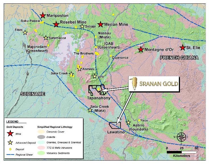
Lawatino and Tapanahony in southeastern Suriname, within the gold-endowed Guiana Shield – near Founders Metals’ Antino, Miata Metals’ Sela Creek and the Merian and Rosebel mines.
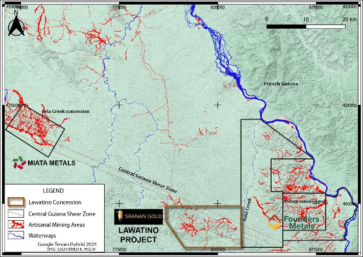
The Lawatino concession on the Central Guiana Shear Zone, with artisanal mining areas in red and the neighbouring Antino and Sela Creek concessions.
Lawatino Project
- 18,468 hectares of highly prospective ground in southeastern Suriname, on the Antino–Sela Creek trend.
- Option to acquire up to a 100% interest in the property.
- Located along the Central Guiana Shear Zone — a regional deformation zone whose late movements influenced mineralization at the neighbouring Antino and Sela Creek projects.
- Extensive artisanal mining within the drainages across the concession.
- Shear-hosted quartz veins occur within granite near contacts with basaltic rocks.
- Two high-grade showings discovered on first-pass reconnaissance — the 101 Zone and the Bodoe Zone — approximately 1.5 km apart along a northwest-southeast trend parallel to the CGSZ.
- Sranan’s first field program — geological mapping, soil sampling, trenching and channel sampling — mobilized in late May 2026.
- Only a small fraction of the 18,468-hectare property has been examined to date.
Fracture Density Model – MUD® SAR
- A fracture density model of the entire concession was generated using Auracle’s MUD® SAR remote-sensing technology, mapping the structural preparation that hosts gold.
- Northwest-southeast linears in the model correspond to the regional Central Guiana Shear Zone, which cuts the concession.
- Areas of alluvial mining correlate directly with — or sit immediately downstream of — areas of high fracture density.
- The model confirmed the structural complexity of the property and identified several high-priority targets, and is being integrated with field geology to rank them.
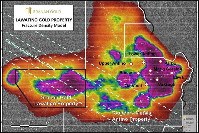
Fracture density map showing structural preparation for gold
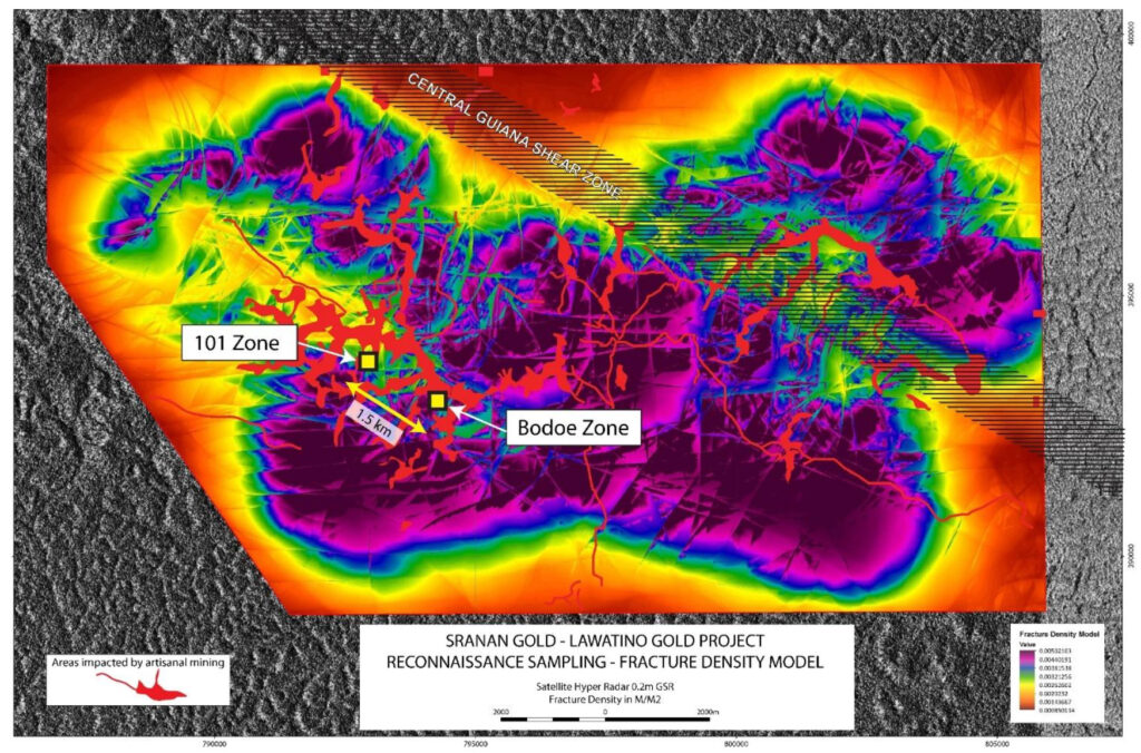
Fracture density map showing potential structure controls for gold deposition
Phase I Reconnaissance Results (July 2026)
- 11 of the first 43 samples assayed returned grades above 1 g/t gold.
- 101 Zone: a mineralized quartz vein carrying semi-massive pyrite in sheared basalt assayed 101.5 g/t gold.
- Bodoe Zone: grab samples up to 15.73 g/t gold, mainly quartz vein float with iron oxide staining.
- Both zones sit in areas of historical artisanal mining and in relatively low fracture-density terrain – ground the regional model had not highlighted, pointing to further potential across the property.
- The 1.5-kilometre corridor between the two zones remains largely untested, and the trend is open along strike.
Selected Phase I Grab Sample Assays
| Zone | Au (g/t) | Sample description |
| 101 Zone | 101.50 | Quartz vein with semi-massive pyrite in sheared basalt |
| Bodoe Zone | 15.73 | Quartz vein float with iron oxide staining |
| Bodoe Zone | 7.25 | Quartz vein float with iron oxide staining |
| 101 Zone | 4.24 | En echelon quartz veins in granite |
| Bodoe Zone | 3.72 | Quartz vein float |
| Bodoe Zone | 2.70 | Quartz vein float |
| Bodoe Zone | 2.07 | Quartz vein float |
| 101 Zone | 1.88 | Weathered iron oxide boxwork |
| 101 Zone | 1.58 | Quartz vein float |
| 101 Zone | 1.43 | Saprolite |
| Bodoe Zone | 1.34 | Quartz vein float |
Grab samples are selective by nature and are not necessarily representative of the mineralization hosted on the property.
Exploration Priorities
- Expose the extent of gold mineralization at the 101 and Bodoe Zones with excavator trenching.
- Cut regularly spaced trenches along the 1.5-kilometre trend between the two zones.
- Continue geological mapping, soil auger sampling, and sampling of exposures and trenches across the property.
- Follow up the high-priority targets identified by the fracture density model.
- Evaluate additional areas of active artisanal mining where no prior exploration has been done.
- Extend remote sensing and complete airborne geophysics over the concession.
- Mobilize drilling equipment and associated facilities, with maiden drilling planned for late 2026.
- Continue reconnaissance of new project opportunities in Suriname.


